Fengyun "seven stars in the sky", what are you "busy"
2022-07-13
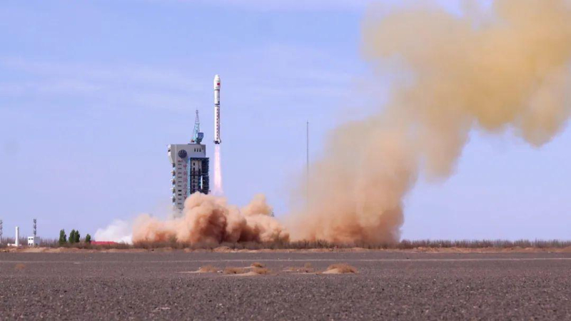
"The main data products of the two 'new stars' of Fengyun meteorology, FengYun-3 E and fengyun-4 B, will be open to global users." Recently, at the 75th session of the Executive Council of the World Meteorological Organization (WMO), Zhuang Guotai, Secretary of the leading Party group and director of the China Meteorological Administration, announced. Can serve the world, what kind of martial arts do these two satellites have? According to reports, FengYun-3 e satellite is the world's first civilian dawn dusk orbit operational satellite, filling the gap in satellite observation data of the global numerical weather prediction model during the dawn dusk period; Fengyun-4b satellite is the first operational satellite of the new generation of geostationary meteorological satellites in China. It has the regional imaging capability of 250 meter resolution at the minute level. The two satellites and their ground application systems were put into operational trial operation in June this year. These are only the two newest members of the "Fengyun family". Up to now, China has successfully launched 19 Fengyun meteorological satellites, of which 7 are in orbit. As keen space outposts, what are they "busy" with in the vast Milky way? People "cold and warm stars": Overlooking the changes These days, rainstorm and high temperature "play the leading role". According to the forecast of the Central Meteorological Observatory, a new rain belt will soon cross the East and West from July 11 to 13, affecting the eastern part of Northwest China to the central and southern parts of North China. Facing the complex weather situation, forecasters have a bottom in their hearts: the Fengyun meteorological satellite constantly monitors the changes of the situation, provides timely and rich observation data, and has a glance at the trend of the air flow. Ren suling, chief service officer of the National Satellite Meteorological Center, said that 10 years ago, Fengyun meteorological satellite generated a cloud map every half an hour or even an hour, with a spatial resolution of several kilometers, while today's fengyun-4 meteorological satellite products have a spatial-temporal resolution of up to 1 minute and 250 meters. Not long ago, Jiangnan and South China suffered heavy rainfall, and the Central Meteorological Observatory issued a rainstorm and strong convective weather warning. In the vast space at the same time, seven Fengyun meteorological satellites keep an eye on the changes of the situation, generate a cloud map of China and its surrounding areas every 5 minutes, and a cloud map of the designated area every 1 minute. Whether it is the rainstorm warning accuracy of 90%, the strong convective weather warning time of 40 minutes in advance, or the first global typhoon forecast... The improvement of China's meteorological forecast level is inseparable from the development of observation technology. "China has made great progress in Typhoon Forecasting, and Fengyun meteorological satellite has made great contributions." Xuyinglong, the chief forecaster of the typhoon and marine meteorological prediction center of the Central Meteorological Observatory, said that in 2021, the fast imager carried by fengyun-4b satellite, which was in the stage of in orbit testing, carried out 1-minute continuous high-frequency observation of Typhoon "fireworks". The combination of geostationary meteorological satellites and polar orbiting meteorological satellites provides important support for forecasters to analyze and judge the impact of typhoon storms in real time. On July 2 this year, typhoon "siemba" landed in Guangdong, and extreme rainfall occurred in many places in southern China. Foshan meteorological observatory issued a tornado warning one hour in advance, which bought time for local disaster prevention and personnel evacuation. Satellite monitoring data can not only accurately reflect the changes of the weather system, but also be integrated into the numerical prediction model through data assimilation technology to further improve the prediction accuracy. It is worth mentioning that for the first time in the world, China has achieved the observation business assimilation of the geostationary infrared hyperspectral atmospheric detector - the fy-4a atmospheric vertical detector, which has improved the prediction accuracy of typhoons, rainstorms and other disastrous weather. In the target observation and assimilation of typhoons such as "Maria" in 2018, FY-4 Meteorological Satellite performed well. Numerical prediction and FY-4 satellite detector "interaction between heaven and earth" carried out target observation and assimilation driven by prediction demand, and the target observation data of the 15 minute resolution detector were assimilated into the global four-dimensional variational assimilation system of the China Meteorological Administration. The results show that the high time and hyperspectral resolution data significantly improve the prediction of the typhoon track and the intensity and location of the subtropical high. Johannes schmetz, former chief scientist of the European Meteorological Satellite Development Organization, commented: "this is a milestone in the assimilation application of geostationary atmospheric sounding." From 2018 to 2021, the scientific research team of the China Meteorological Administration carried out a total of 9 target observation assimilations, and the 24-hour and 48 hour path forecasts of typhoons increased by an average of 10%. Grain "Guardian Star": "Insight" knows the sky and works As the saying goes, "eat from the sky", meteorological conditions have an important impact on agricultural production, and satellites are a pair of "eyes" to capture meteorological conditions and agricultural production. This year's summer harvest is a tough battle. In 2021, northern China experienced a rare autumn flood, with delayed sowing dates of winter wheat and deviated seedling conditions in many places. It was a great challenge to achieve a good summer harvest. "In order to win this summer grain defense war, the meteorological department strengthened the linkage with agricultural and rural departments and major grain growing provinces in terms of satellite remote sensing, established a linkage mechanism for agricultural meteorological remote sensing monitoring at the national and provincial levels, comprehensively studied and judged the growth of Winter Wheat by using Multi-source Satellite remote sensing data, timely provided the relevant departments with the analysis report on the growth of crops and the impact of meteorological conditions, and provided strong technical support for the relevant departments to carry out winter wheat spring management work. ”Wu Menxin, a senior engineer at the research level of the National Meteorological Center, said that now the wheat harvest is coming to an end, the harvest is good, and the agrometeorological remote sensing service has been highly praised by all parties. From "watching the sky and eating" to "knowing the sky and working", satellite remote sensing makes agricultural production from unknown to known, and turns passivity into initiative. "The essence of Agrometeorological remote sensing is to qualitatively or quantitatively evaluate the impact of past and future meteorological conditions on crop growth. Quickly and accurately mastering the spatial distribution of crop planting can improve the spatio-temporal matching accuracy of crop planting distribution and meteorological element distribution, which is of great significance to improve the accuracy of agrometeorological disaster monitoring and early warning and crop yield meteorological prediction." Zhangmingwei, an associate researcher of the National Satellite Meteorological Center, said that in May this year, the "national provincial city / county" integrated remote sensing monitoring system for the distribution of bulk crops of the China Meteorological Administration was initially completed, and the high spatial resolution remote sensing products for the distribution of winter wheat were first applied to the meteorological forecast of summer grain crop yield and the monitoring and early warning of agrometeorological disasters of the China Meteorological Administration, adding a "sharp weapon" to ensure a good harvest of grain. In order to realize that "the rice bowl mainly contains Chinese grain", we should also strengthen the monitoring and management of China's major grain crops. In recent years, the China Meteorological Administration, the Chinese Academy of Sciences, the Ministry of agriculture and rural areas, etc. have used Fengyun meteorological satellite data as a data source to carry out meteorological disaster monitoring in important grain producing areas at home and abroad, as well as growth monitoring and yield estimation of major grain crops such as wheat, corn, rice and soybeans, which provide an important and reliable reference for scientific decision-making. "Agrometeorological disasters have a great impact on China's grain production, of which drought has the most serious impact." According to maokebiao, a researcher of the Chinese Academy of Agricultural Sciences, surface temperature and soil moisture are important parameters in drought monitoring. Previously, relevant data were mainly obtained through meteorological stations, but the stations are relatively sparse, the spatial representation is not enough, and the manual method is time-consuming and laborious. It is understood that with the development of meteorological satellites, the number of bands and radiation resolution are constantly optimized. Its infrared remote sensing data can retrieve the surface temperature, and the microwave brightness temperature data can retrieve the soil moisture, which provides strong support for meteorological disaster monitoring and early warning, crop growth monitoring and yield estimation. Based on Fengyun meteorological satellite data, the quantitative inversion of crop and farmland environmental parameters by remote sensing provides reliable key parameters of crop growth for crop growth models, data assimilation systems, crop yield estimation and other applications, and provides a valuable reference for field agricultural management. With the trial operation of FY-3 e satellite, FY-4 B satellite and their ground application system business, there will be more possibilities for the development of agricultural satellite remote sensing business in the future. Ecological "monitoring star": Empowering beautiful China "Satellite monitoring images showed that cyanobacteria blooms appeared in the western coastal area and the central area of Taihu Lake." Recently, a meteorological satellite monitoring report was sent to the office of the China Meteorological Administration, the Jiangsu Provincial Meteorological Bureau, the Department of ecological environment, the Department of water resources and other relevant departments. Subsequently, a department linked and territorial coordinated blue-green algae prevention and control action was carried out rapidly, realizing the early discovery, early intervention and early disposal of blue-green algae blooms. This is due to the strong ground monitoring ability of Fengyun meteorological satellite. Among them, the static meteorological satellite can provide 5-minute monitoring of China and its surrounding areas, and can generate cloud images of designated areas once a minute. The three polar orbiting meteorological satellites can provide 6 high-resolution monitoring covering the world every day. According to reports, using the advantages of multi satellite networking and collaborative observation, Fengyun meteorological satellite can also realize the dynamic monitoring and evaluation of global and key regional ecological environment conditions with high temporal and spatial resolution, helping decision-making departments to respond faster. Chahannaoer lake, located at the junction of Shangdu County, Wulanchabu City, Inner Mongolia Autonomous Region and Kangbao County, Zhangjiakou City, Hebei Province, is the largest inland salt water lake in North China. In the past, due to the lack of systematic protection, the ecosystem was seriously damaged. In 2020, a special cooperation mechanism for the protection and restoration of chahannoer wetland in Inner Mongolia and Hebei was established. Two years later, what is the progress of ecosystem restoration in chahannoer? "Compared with the same period last year, the vegetation index of chahannoer region increased by 8.5% in April, and the water area increased by 0.2 square kilometers." This special report with clear data is made based on the data of FengYun-3 meteorological satellite, which provides an important basis for evaluating the ecological environment management of chahannoer. Through satellite broadcasting, Internet and remote sensing application business system, Fengyun meteorological satellite data and products have been widely used in ecological monitoring. The National Satellite Meteorological Center has also established long-series satellite remote sensing data sets of vegetation, surface temperature, water body, cyanobacterial bloom, sand dust and snow since 2000, and jointly compiled more than 10 technical guidelines for vegetation, urban heat island, water body, cyanobacterial bloom, sand dust, snow and fire. The satellite remote sensing application system (SMART) versions 2.0 and 3.0 have been developed, used in national meteorological departments, and extended to many countries. In June this year, FY-3 e, FY-4 B and their ground application systems were put into business trial operation. Hanxiuzhen, chief service expert of the China Meteorological Administration and senior engineer at the research level of the National Satellite Meteorological Center, introduced that the low light level medium resolution spectral imager carried by FengYun-3 e satellite has the ability to monitor light information in the morning dusk orbit, and can realize the dynamic monitoring of urban light images. With the double stars shining in space, its ecological monitoring ability has been further enhanced. At present, China has provided Fengyun satellite data and products for 124 countries and regions, including ecological environment and natural disaster monitoring and assessment. 30 countries have registered as international users of the emergency safeguard mechanism, and opened green service channels for 42 countries. More than 1200 students from more than 100 countries have received special training on Fengyun satellite applications. Our "ecological circle of friends" is expanding day by day. (Xinhua News Agency)
Edit:Li Jialang Responsible editor:Mu Mu
Source:gmw.cn
Special statement: if the pictures and texts reproduced or quoted on this site infringe your legitimate rights and interests, please contact this site, and this site will correct and delete them in time. For copyright issues and website cooperation, please contact through outlook new era email:lwxsd@liaowanghn.com

 Recommended Reading Change it